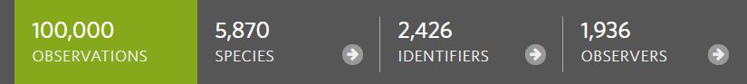
Congratulations to all who have contributed such amazing observations. The first 100k took quite a while, with the first observation from SA in mid-2011, reaching only 100 by mid-2013 and 1,500 by mid-2016. In fact, 95% of all observation in SA have been uploaded since the beginning of 2018. We are currently adding a new observation approximately every 7 minutes!
The number of local contributors is now growing rapidly. At the current rate of growth we are likely to reach 200,000 observations in less than 12 months. So keep those observations coming. 5,870 species represents only a small fraction of the biodiversity of our state. There’s still so much to discover.
Estimates of the number of new species described vary and change year to year. The highest rate was estimated to be prior to WW1 with around 1400 new species described annually. More recently the rate has been near half of this. Even at 1000 new species described annually, we’d be looking at 420 years before we could have a complete catalogue. With a 10% decline in the taxonomic workforce at major institutions over the last 25 years, something needs to change.
The website lists 763 new Australia species described in 2019. See the full listing on the Taxonomy Australia “Discoveries Dashboard”. (Links through to the pages listing the papers may take a moment to load).
The Venus Fly Trap or perhaps a Pitcher-Plant might be the typical images conjured up when considering carnivorous plants. However there are over 500 species of carnivorous plants worldwide to choose from. If you keep an eye out during the cooler months in SA and you might find any of the 21 species of local carnivorous plants, including several that are endemic to SA.
One of the filtering options that is not currently available on the “Explore” page is the option to remove the obscured observations from the Map view. This means that the map view of populated areas can sometimes look cluttered with obscured observations making it difficult to see the pins for observations with public locations. The below URL can be used to return a page where the obscured observations have been removed from the map view. Keep in mind this will remove not only the observations users have chosen to obscure, but also those obscured automatically for conservation reasons.
Observation from iNaturalist are synced with ALA but the details on frequency of syncing, refreshing of records and which observations were synced have been a little unclear. The process has been explained by ALA HERE, and is worth quoting in full below:
Data is harvested from iNaturalist Australia to ALA daily. After processing, it is refreshed once per week.
Observations will come across to the ALA if they are:
Shareable under a Creative Commons license In Australia Verifiable observations – those which are marked Needs ID or Research Grade
If an iNaturalist observation is updated with a new identification, image, or a changed location, the record in ALA will be updated as part of the regular data harvest.
If records are removed from iNaturalist, they will be removed from ALA.
So which site should you use? This iNaturalist Blog post explains most of the differences with comments from some ALA staff.
By making iNaturalist Australia your “iNaturalist Network Affiliation”, ALA will be given access to the location data of your obscured observations. This will provide those using the ALA data for research and conservation efforts with more valuable information. To make this change, head to your iNat User Profile and select “Edit Account Settings and Profile”. Scroll to the bottom of the settings page and change your “iNaturalist Network Affiliation” to “iNaturalistAU”
There are more than 350 native Orchid species in South Australia. While some have distinct characteristics that make identifying them relatively easy (when flowering), others can be a lot more difficult. Below I’ve compiled some resources that should help to aid both the beginner and experienced enthusiast in identifing local Orchids.
Shifting Baseline Syndrome (SBS) describes a gradual change in the accepted norms for the condition of the natural environment due to a lack of human experience, memory and/or knowledge of its past condition.(1) In the absence of past information or experience with historical conditions, members of each new generation accept the situation in which they were raised as being normal.(2)
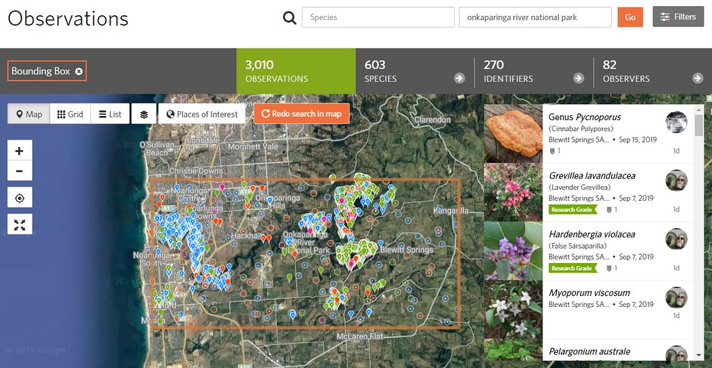
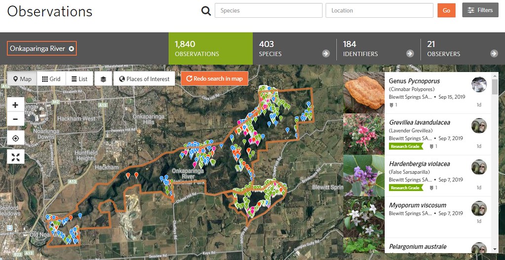
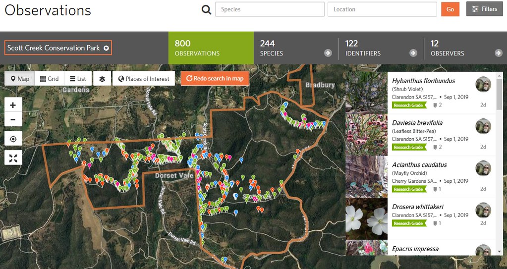
One of the first things I wanted to do when I began using iNat was to find out what species had been seen in various conservation areas I wanted to visit. I used the Explore page and searched for Onkaparinga River National Park, which returned an over-sized rectangular Bounding Box around the park that also included observations from lots of other areas I wasn’t interested in. I tried the same for Scott Creek Conservation Park and it returned a Bounding Box far smaller than the park. This wasn’t quite what I was after.
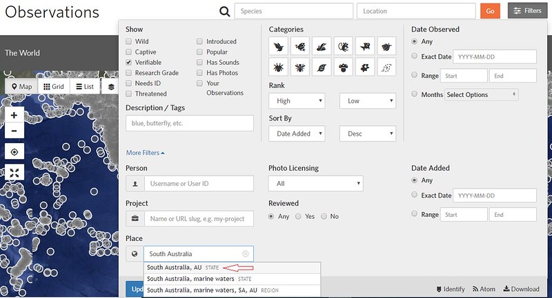
iNaturalist “Places” iNaturalist has some built-in locations that can be searched. These are “Standard Places”. For example, enter “South Australia” into the search location box and you can select that standard location from the down-down list. However, many local places are not listed at all. This is where the “Community Curated Places” come in. Any user (with at least 50 observations) can create their own place, with any boundary that they choose, and save it to the iNat database of places. These places can then be used by any iNat user through the search filters, or the place can be added to a Project. To search or add Places, click the “More” drop down menu in the iNat page header and select “Places”. (https://www.inaturalist.org/places).
How to Search Community Curated Places The Community Curated Places don’t appear when typing the place name into the location box on the “Explore” page. This appears to be restricted to the Standard Places. To search for a community curated place, on the “Explore” page open the “Filters” box, click the “More Filters” button to expand the filtering options, then in “Place” type in the community curated place name and select it from the dropdown list.
After creating the necessary community curated places, I could now use the above search/filter method to return observations from much more accurate locations.
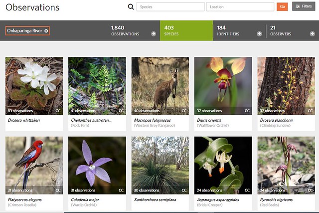
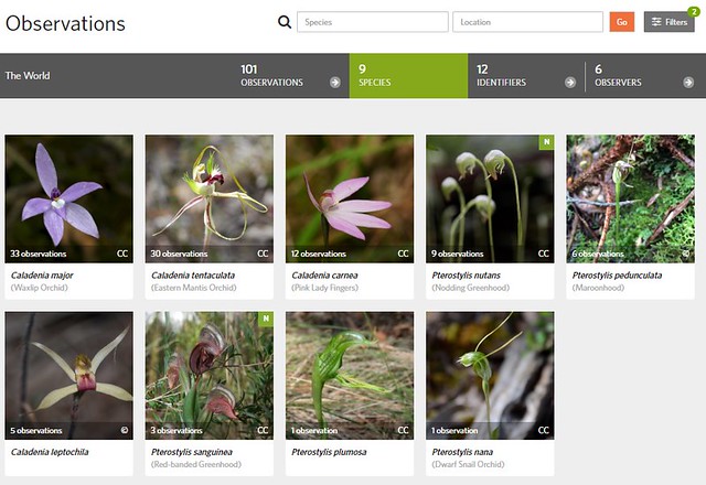
Which Species Have Been Seen? Using the above search will return a full list of observations, in date order, from within that place. To see a summary list of which species have been observed, select the “Species” tab below the search boxes (shown below). This will return a grid list of the species observed in the place in order of frequency seen. Provided the place has a good number of observations, this can provide a guide as to what you are most likely to see when visiting the place.
If you have a particular interest area, further filters can be applied to narrow the search to particular taxa, i.e. Lepidoptera in Onkaparinga River National Park
Currently Existing “Places” in SA Finding that many interesting places in SA were not listed, I set about creating places I wanted to be able to search, and then creating places I wanted to visit, eventually putting many of them together in a single Umbrella Project covering the Protected Parks of South Australia. Each of the places in this project are now searchable using the above filtering methods. There are also a growing number of local marine and coastal places being added to the iNat places database and used in various projects. There are presently 554 places listed within South Australia.